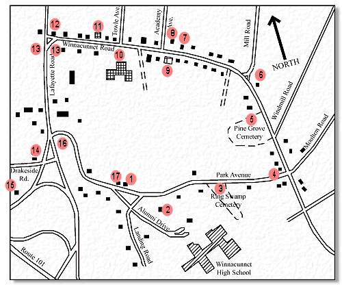
- Point 1
- The Meeting House Green. Site of the first four meetinghouses and the first Hampton Academy building. The center of town activities from 1638 to the early 19th century. Founders’ Park, in the triangle, was established in 1925 to honor the early Hampton families.
- Point 2
- Emery-Jackson House, 47 Park Avenue. Home of two 18th-century physicians, Clement Jackson and Anthony Emery.
- Point 3
- Ring Swamp Cemetery, opened in 1799. The second town cemetery with iron gates made by a local blacksmith, Enoch Young.
- Point 4
- Enoch Young’s House, 86 Park Avenue. The house dates to the early nineteenth century.
- Point 5
- Pine Grove Cemetery, before 1654. This is the oldest public cemetery in the state, where most townsmen were buried before 1800. The oldest stone still standing dates to the late 17th century.
- Point 6
- 188 Winnacunnet Road. Site of the Morris Hobbs house, where the newly-formed Congregational Society met 1796-97, after separation from the town church and before their meetinghouse was built.
- Point 7
- Site of the 1797 Congregational meetinghouse, later the town hall. The old building burned in 1949.
- Point 8
- Hampton District Courthouse. The building was the old Cen-tre School, built in 1873, one of four grammar schools in town. This, the only one to still stand, was moved here in 1922 and raised on a high basement to house the fire department in the cellar.
- Point 9
- Congregational Church, 1844. The chapel was added in 1873. This was the first Congregational meetinghouse not to have been owned by the town.
- Point 10
- Centre School, 1922. This has been the site of a school since the 18th century.
- Point 11
- Baptist Church, 1834. The Baptist Society was formed in 1817, the second religious society in the town. This is now the oldest church building in Hampton.
- Point 12
- The site where George Whitfield, the great English evangelist, preached in 1740, sparking a religious revival in the area.
- Point 13
- The sites of the Toppan houses, facing each other across Lafayette Rd. The Toppan family was prominent in Hampton for over a century as merchants, lawyers, politicians, and historians. Christopher Toppan donated the site for the 1797 meetinghouse, and a descendant gave the land for the present Hampton Academy.
- Point 14
- The David Towle House, built in the mid-18th century in North Hampton and moved to this site in the 19th century.
- Point 15
- The General Jonathan Moulton House, 1769. The only high-style Georgian house in Hampton, this house has been the focus of a number of ghost stories and tales of dealings with the Devil.
- Point 16
- Rand’s Hill (now part of Park Avenue). The site of Hampton’s earliest tavern, operated by Robert Tuck, and supposedly the site of the home of the accused witch Goody Cole.
- Point 17
- Site of the Samuel Harden house. The Tuck Museum stands on the land which the town allowed to Samuel Harden, a War of 1812 veteran. He was the town sexton for decades.
|